The Society helped fund this survey looking for signs of early humans in Scotland.
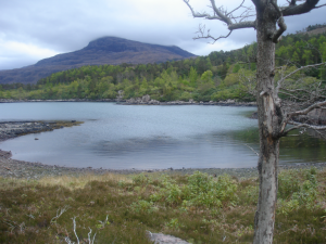
Lub Dubh Aird (LDA 1) with rockshelter in the distance.
Lub Dubh Aird is a small, low lying bedrock promontory on the south shore of Upper Loch Torridon. The east facing coastline has three bays, two of these lie at the landward end of the peninsula, they consist of a mixture of sand and small gravel overlain by small to large angular rocks with some areas of bedrock. The third bay is near the tip of the peninsula, and is covered in beach pebbles.
Lub Dubh Aird was brought to our attention by two local residents, Andrew Patrick, who has been collecting lithics in the intertidal zone here for several years and Mary MacDonald who had also found a nearby rockshelter containing a shell midden.
During fieldwork (April – July 2012) a total of four different locations, including the three bays and the rockshelter, produced lithics though the main bay at Lub Dubh Aird (NG 8723 5505, site name LDA 1) was the most prolific.
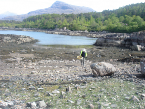
Lub Dubh Aird 1 survey
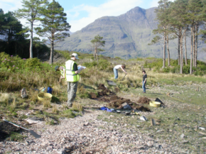
Lub Dubh Aird test pitting
A 5 x 5m grid was created and a walkover survey was conducted across LDA 1, main bay; this confirmed the presence of lithics across the beach.
Nine test pits (approx. 1m x 0.5m) were laid out above LDA 1. Test pits 1, 6 and 7 were laid at the beach edge while the remainder were further up the slope and away from the beach. Only test pit 1, which was placed directly above the most prolific source of beach lithics, produced substantial numbers of lithic artefacts (100 pieces).
A rockshelter ( NG 87350 54981, LDA 3) which faces directly onto Upper Loch Torridon, lies approximately 100m to the south west of the bay and 2m above the high water mark was also investigated with a small test pit.
Most of the lithic finds come from LDA 1. (Table 1). They are made on a range of raw materials, including flint nodules which are found in the beach, and quartzes and quartzites. Most of the lithic artefacts, which consist largely of bipolar flakes and waste supplemented by handfuls of hard percussion flakes, were found in the small-beach-gravel which occurs across the beach and continues under the peat for a short distance. The recovery of finds predominantly in the tidal zone, the presence of two possible broad blades, and the single thumbnail scraper indicates a likely earlier Mesolithic age. The strongly bipolar nature of the technology is unusual however, though it may be related to the very small nature of the flint nodules. The lithics have a sharp, unrolled appearance which suggests they were deposited without significant water rolling perhaps soon after production.
Table 1. Lithic producing sites.
| Site name | Grid reference | Number of lithic artefacts |
| LDA 1, main bay | NG 8723 5505 | 2754 |
| LDA 2, small bay between LDA 1 – LDA 3 | NG 87198 55028 | 12 |
| LDA 3 rockshelter | NG 87350 54981 | 17 |
| LDA 4, larger bay at north end of peninsula | NG8692 55257 | 8 |
The rock face and original rockshelter clearly suffered a collapse at some point probably in late prehistory. The current ‘rockshelter’ is in fact an accumulation of large boulders covered by a huge slab which is perched on boulders, around 1.5 m above the surface while the position of the deposits in the rockshelter, which includes lithic material only present on the surface, suggest the stratigraphy may be partially inversed. Lithic artefacts found in amongst rocks below the shelter suggest that some deposits washed down the rock face and onto rock platform.
The high concentration of artefacts found at the upper part of the beach near and in Test pit 1, and a concentration of fire-crazed artefacts here suggests the original source was close by. The lithic assemblage is however challenging, in that it does not fit easily into the cultural templates for the region. Is the extensive use of bipolar technology a local adaptation to the small beach pebbles that are available or is there a cultural or functional motive that we are not aware of? Only further work in the area can attempt to resolve this.
We began by thinking that the buried peats at the top of the beach were the source of the lithics and the sharp nature of the lithic artefacts suggests they were deposited without significant water rolling perhaps soon after production. Following our fieldwork, we believe the source area of the lithics to probably derive from two discrete areas; deposits in and around the rockshelter, and production of artefacts occurring at the back of the beach, possibly into the edge of the beach, as the small assemblage found under the peat in test pit 1 suggests, with the debitage, cores and flakes being reworked around the beach by the tides. The collapse of some of the rockshelter may also have introduced more lithic material into the cove which also washes onto the beach.
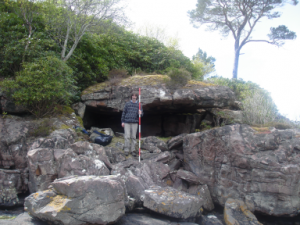
Lub Dubh Aird rockshelter
Lub Dubh Aird is a wonderful example of a small prehistoric landscape. It combines a rockshelter which lies in a sheltered yet commanding position with clear views across Upper Loch Torridon. The fact that lithic artefacts were found in four different locations allows for a perspective of small scale movement that is often missing when the focus is on the ‘site’; instead Lub Dubh can be construed as a prehistoric landscape.
The raw materials and lithic working methods are entirely different to the Mesolithic assemblage which was found nearby at Shieldaig. This suggests that they were not contemporaneous and represent different time periods over the 4000 or so years of the Mesolithic. The nature of the assemblage suggests that primary knapping was conducted on or near the edge of the beach at LDA 1. In a broader perspective, Lub Dubh can be integrated into the widespread evidence for the Mesolithic in Loch Torridon and into the wider Inner Sound area which is rich in early prehistoric sites. Though no systematic investigation has as yet taken place to the north of Loch Torridon, it is very likely that further evidence of early prehistoric people would be found here too.
This project represents collaboration among a wide range of different people and entities and this proved to be very productive in terms of the project’s outcomes. The project was initiated based on the finds of two members of the local community, Andrew Patrick who alerted local archaeologist Martin Wildgoose and Mary MacDonald who had contacted Karen Hardy several years earlier. Collaboration was established with Wessex Archaeology who provided terrestrial manpower and underwater and geomorphological expertise. Torben Ballin conducted the summary lithics report.
This report is a summary of the Data Structure Report authored by Hardy K, Benjamin J, Bicket A., McCarthy J, Ballin T. The project was funded by the Society of Antiquaries of Scotland, Ministry of Science and Innovation Spain and Wessex (WA) Archaeology. The landowners, Duncan Grey, and Michelle Bianco are thanked for giving permission to conduct this project on their land and to Murdoch MacDonald, and Carol Dickson who also assisted with the fieldwork.
Help us: champion research; stimulate discussion; enhance public understanding; and share our extraordinary heritage. Donate directly to the Society now.