Geographies of Power and ‘Places in Between’ at Iron Age Bemersyde
Two complimentary projects investigating a significant Iron Age site
The Society of Antiquaries of Scotland funded two projects, led by Dr Tanja Romankiewicz FSAScot and Dr Kirsty Lilley FSAScot, relating to research on the prehistoric sites at Bemersyde in the Scottish Borders.
Introduction
The work comprised fieldwork and laboratory analysis of a complex prehistoric settlement site with Roman finds, within 3 km of Newstead Roman Fort. The radiocarbon dating and geoarchaeology undertaken as part of the project were funded by the Dr Euan MacKie Legacy Fund available from the Society of Antiquaries of Scotland.
Situated within the wider European project Geographies of Power (jointly directed by Dr Tanja Romankiewicz, University of Edinburgh and Dr Andrew Lawrence, University of Bern, with fieldwork co-director Stuart Campbell, Trimontium Trust), our research seeks to contextualise the site’s position in both its physical and political landscape, in what was once the northern frontier zone of the Roman empire. Employing a multi-method approach, including excavation, geophysical survey, systematic metal detecting, palaeo-environmental sampling and post-excavation analysis, this project brought together academics and specialists with students and members of the local community, and specifically with volunteers from Trimontium Museum and Trust. Dr Kirsty Lilley joined the second year of excavations in 2024.
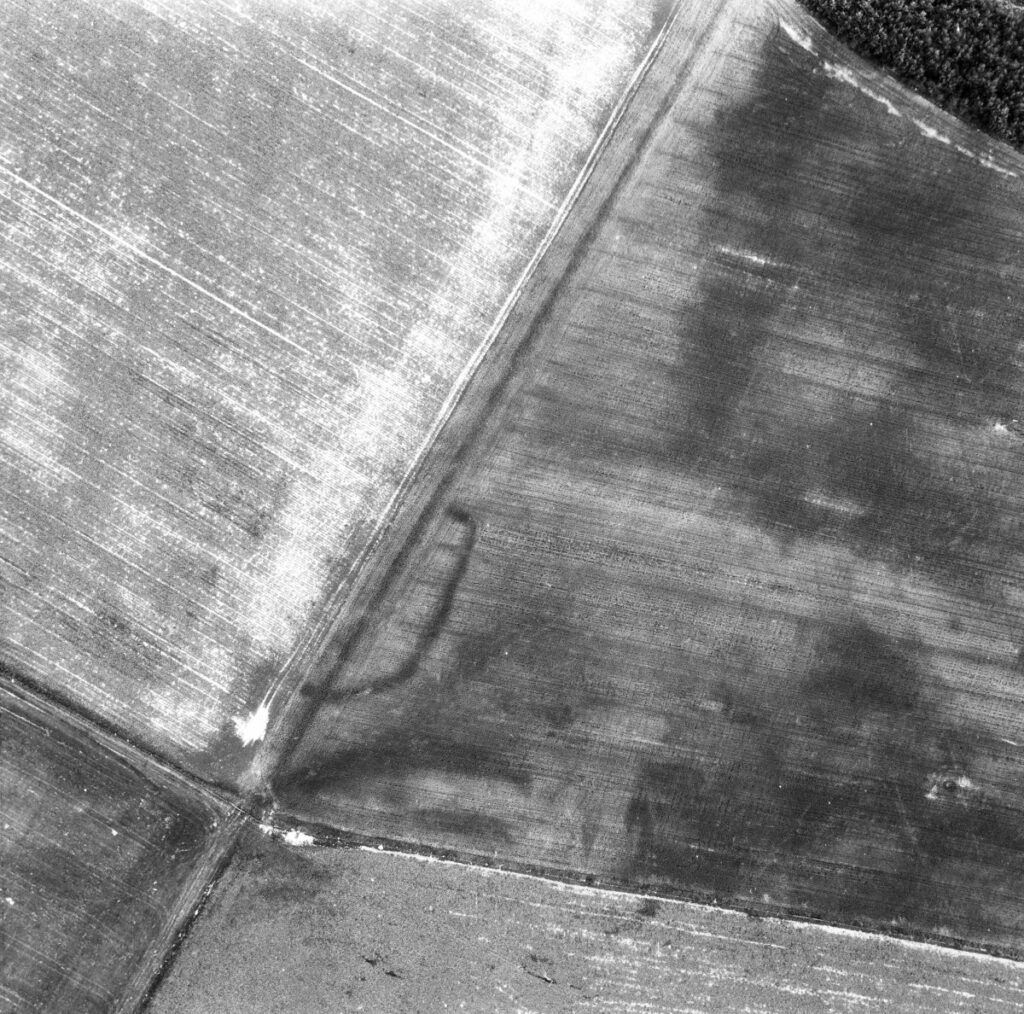
Cropmark at Bemersyde showing the outer ditches of the curvilinear enclosure and the single ditch of the rectilinear enclosure © HES
The Bemersyde sites, consisting of one curvilinear and one rectangular enclosure (Atlas of Hillforts entry SC4007, Trove IDs 55662 and 57249) are located on the SE flank of Bemersyde Hill, and have been initially identified from cropmarks in aerial photography. Whilst no upstanding features remain on the surface, aerial imagery indicates a curvilinear enclosed settlement, with a likely entrance to the east, and a rectilinear enclosure immediately to its ENE. Small-scale excavations at the curvilinear site were undertaken in 1990 by Dr John Dent as part of the Newstead Environs Project, and at both enclosures in June 2023 and July 2024 by the Geographies of Power project. The aim of the 2024 season was to continue investigations of the defences and internal structures, as well as to understand the ‘places in between’: offering a multi-scalar perspective on the relationships between the two enclosed sites, between the multiple surrounding ramparts and ditches, and with the wider landscape.
Excavation and Post-excavation
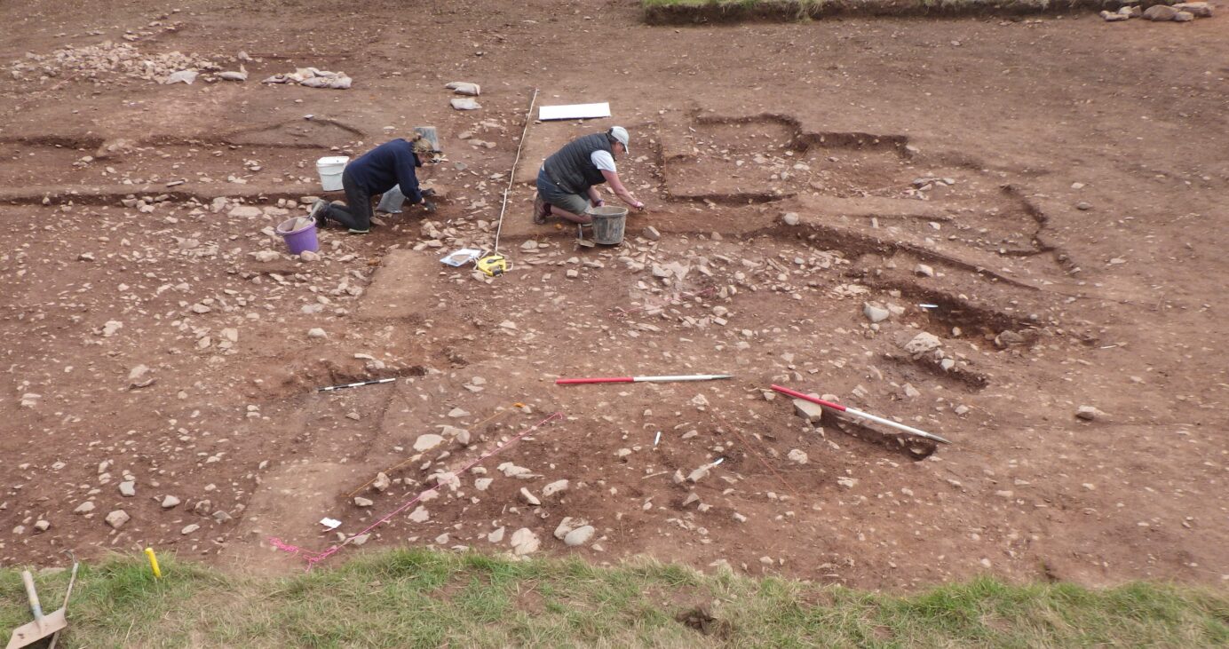
Two trenches were opened in 2024: one over a roundhouse, expanding from the 1990 and 2023 excavations, and a second one across the ditches and rampart system in the location of the 1990 and 2023 trenches. Mechanical stripping allowed to quickly expose the previous seasons’ work, and to increase the depth of investigations.
The roundhouse footprint was fully exposed, revealing a ring-groove seemingly overlain by a later, amorphous paving to its east. Both structures were associated with possible hearths and cooking pits and extensively sampled for geoarchaeological analyses in the University of Edinburgh’s Analytical Heritage Sciences lab, in collaboration with Teesside University’s geochemical laboratory facilities.

Ring-grooved roundhouse under excavation in 2024 © Tanja Romankiewicz
A short distance to the SW of the roundhouse, an elongated paved area may have been a walled structure rather than an open yard, since initial geochemical analysis suggests that chemical signatures differ sharply between the zones identified as internal or external to the sub-rectangular paving. If roofed, the building would have likely been enclosed by a turf wall over rubble foundations. An undergraduate dissertation in 2024/25 at the University of Edinburgh investigated the results from the chemical analysis undertaken by Dr Vanessa Reid (University of Edinburgh) as part of the Society’s grant. The thesis identified patterns consistent with other Iron Age structures within hillforts, where similar analysis had been undertaken. More analytical work will be undertaken now to characterise the different activity zones, especially since a Roman brooch has been found associated with this structure. While not included in a first batch of radiocarbon dates, more dates are being processed to confirm the sequences of use in this area. If the oblong structure is contemporary with the roundhouse, we may be seeing architectural distinctions within the confines of the curvilinear enclosure, perhaps reflecting different functions.
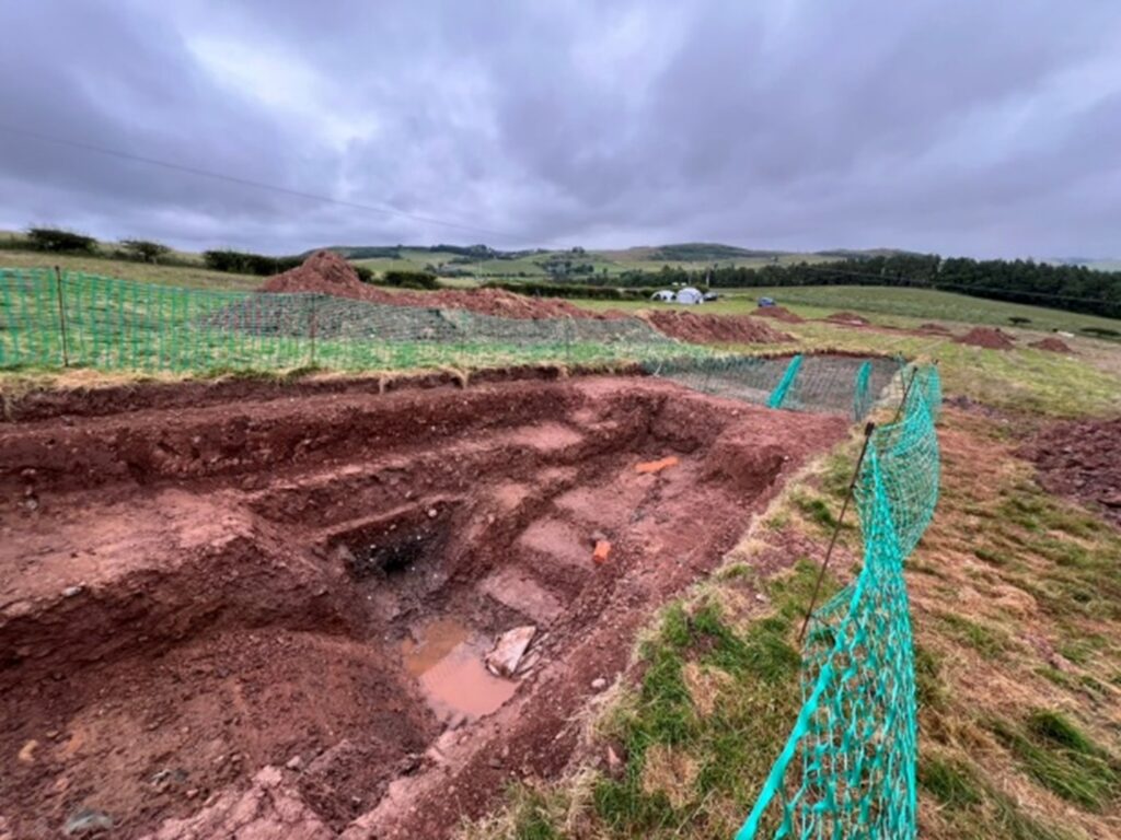
A deep trench across multiple ditches © Kirsty Lilley
In the second trench, at least 9 possible ditch cuts and recuts were identified, enlarging the previous interpretation of only three concentric ditches and indicating successive episodes of remodelling of the ramparts connected with repeated activities at the site. Several ditches contained waterlogged wood with tool cutmarks, which are currently analysed for their work patterns and C14 dating. All this will feed into our wider research to disentangle the occupation sequence and to determine whether the remodelling of the defensive systems related to the Roman presence at Trimontium.
The external rectilinear enclosure to the ENE of the hillfort, partially excavated in 2023, was not reopened in the 2024 season, but the recovery of prehistoric pottery associated with organic material from the ditch fill should help with dating the feature. A further programme of radiocarbon dating and extended paleoenvironmental analyses are in progress, including an analysis of the macroplant and micromorphological samples.
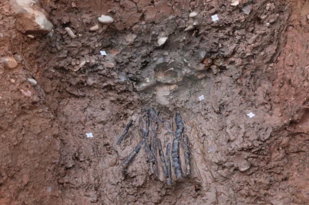
Waterlogged wood at the bottom of the ditch © Kirsty Lilley
In the context of the ‘places in between’ project part, the proximity of both enclosures to each other, and their possible co-existence or referencing of each other’s structural presence in the landscape, suggests that such earthworks were not (always) barriers nor binary distinction between inside and outside. Instead, despite a landscape densely populated with enclosures, the region could have seen activities at different times within and outside of the bounded sites that remain visible today. The Geographies of Power project is only beginning to tease out more complex relationships between the people, places, and landscapes in this period.
Survey
Key for understanding the more ephemeral ‘places in between’ is further survey work. As a recent PhD graduate with significant fieldwork experience, her part of the project allowed Kirsty to develop skills in geophysical survey (predominantly earth resistance, with some magnetometry), and community engagement through ongoing volunteering with Trimontium Museum. Kirsty was also able to adapt existing knowledge of excavation and recording techniques (and pottery identification even in very muddy conditions!) to the conditions of the Iron Age material recovered in the Scottish Borders and to deepen her familiarity with the archaeology of later prehistoric Scotland overall. The project also led to new employment for Kirsty, first as a research assistant at the University of Edinburgh (to work on laboratory analyses as well as with digital data processing), and more latterly with Trimontium Museum, where Kirsty is currently employed as their archaeology support officer. The role involves the delivery of an active programme of community archaeological fieldwork – with many of the volunteers who joined us at Bemersyde – where Kirsty helped to train volunteers in survey and recording techniques and assist with finds processing. Experience certainly goes both ways: the Trimontium Trust volunteers bring a rich and diverse knowledge of local landscapes and communities, and more specialised experience of, for instance, historical metal detecting finds or 3D documentation – and these are conversations that will foster Kirsty’s work in the future.
Summary
The completed excavations at Bemersyde, together with continuing palaeoenvironmental research and post-excavation analyses, are deepening our understanding of later prehistoric settlement in lowland Scotland. The site’s unusual placement on a hillslope, rather than a hilltop, indicates that even within a relatively small region, Iron Age communities adopted differing strategies for engaging with the landscape. Further work will help to clarify how such enclosed sites related to their immediate surroundings and the Roman presence in the area.
We are extremely grateful to the Trimontium Trust and Dr Stuart Campbell in particular, and everyone else who contributed to the project, and to the Society of Antiquaries of Scotland for their support – and we look forward to future work on the site.