
The archaeological landscape of North Roe, Shetland
A multidisciplinary project in Scotland’s northernmost islands
Society funding was awarded to Dr Will Megarry FSAScot for the continuation of a project focused on human-landscape interactions in the area around the riebeckite felsite quarries of Shetland’s Northmavine peninsula.
Overview
Felsite is a bluish igneous rock which has been exploited for the production of polished stone tools since the early Neolithic. The felsite quarries were mapped as part of the North Roe Felsite Project (NRFP), which ran from 2013–2017. The project also excavated and radiocarbon dated several quarry pits, categorised and geochemically provenanced felsite artefacts and mapped their distribution across the archipelago (Cooney et al. 2011, 2019; Ballin 2017; Megarry et al. 2018, 2021). In April 2022, The Society of Antiquaries of Scotland previously funded the partial excavation and mapping of a prehistoric building (Structure D) close to the felsite quarries at Grut Wells.
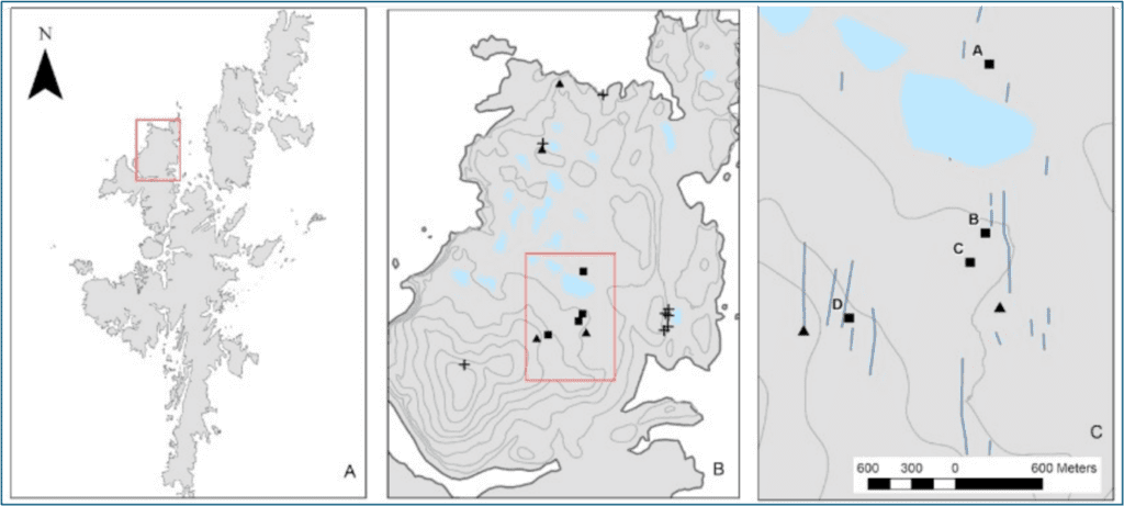
Location of surveyed and excavated buildings in relation to other structures (▪) burial cairns (+) stone tool workshops (▲) felsite dykes (/) (data from NRFP 2019). Structure D and Structure B were subject to investigation in 2024.
This consisted of an oval drystone structure with a large central hearth covered by a large stone, and the internal space partitioned by a combination of pillars and orthostats, along with a smaller circular ancillary building. Charcoal from the hearth was radiocarbon dated to the middle Bronze Age (1874-1672 cal BC; UBA-43169, 3422 ± 32 BP), considerably extending the demonstrable timescale of archaeological activity in the Grut Wells area. The 2024 fieldwork, which took place between 2nd–8th June, sought to complete the excavation and recording of this structure and establish a chronology for its construction and occupation. In addition to this, the project digitally recorded a second structure (Structure B).
Results of the 2024 season
The interior of the building was partly filled with a layer of tumbled stones (C5) was exclusively composed of granite blocks between 0.08–1m across, which must have originally formed part of structure walls. Measuring 1.4m x 0.6m and c.0.12m thick, a large flat stone north-west of the hearth may be a fallen orthostat.
It is comparable in height to the adjacent stone wall extant at the north side of the structure and of similar dimensions to the orthostat that separates the north-west and south-west alcoves. Where possible, tumble layer C5 was removed but stones were left in place where their removal might have compromised the stability of the standing walls, which reduced the area available for excavation particularly in the south-east alcove.
Beneath the granite tumble, irregular floor surfaces were revealed. Contexts were assigned individually to the surface within each alcove so that finds and environmental samples could be clearly provenanced, enabling any spatial heterogeneity in occupation activity to be identified, although in fact, both archaeological and archaeobotanical material was extremely sparse in these contexts.

Open day tour at Structure D
The hearth
Excavation of the hearth structure itself suggested one main phase of occupation with no clear evidence of remodelling or reworking. The hearth was constructed of uncoursed granite blocks bonded with clay. When the hearthstone was lifted, a layer of partly heat-reddened silty clay (C16) was revealed, concentrated at the southern end of the hearth. This appeared to have been burnt in situ and sampling revealed that this contained fragments of charcoal. Preliminary analysis of sampled material suggests that the major fuel was heather and peat, which is consistent with what has been found at other sites across Shetland during the early Bronze Age (Whittle et al. 1986: 133; Downes & Lamb 2000: 10). Small patches of redeposited burnt clay were found on the adjacent surfaces C12 and C13.
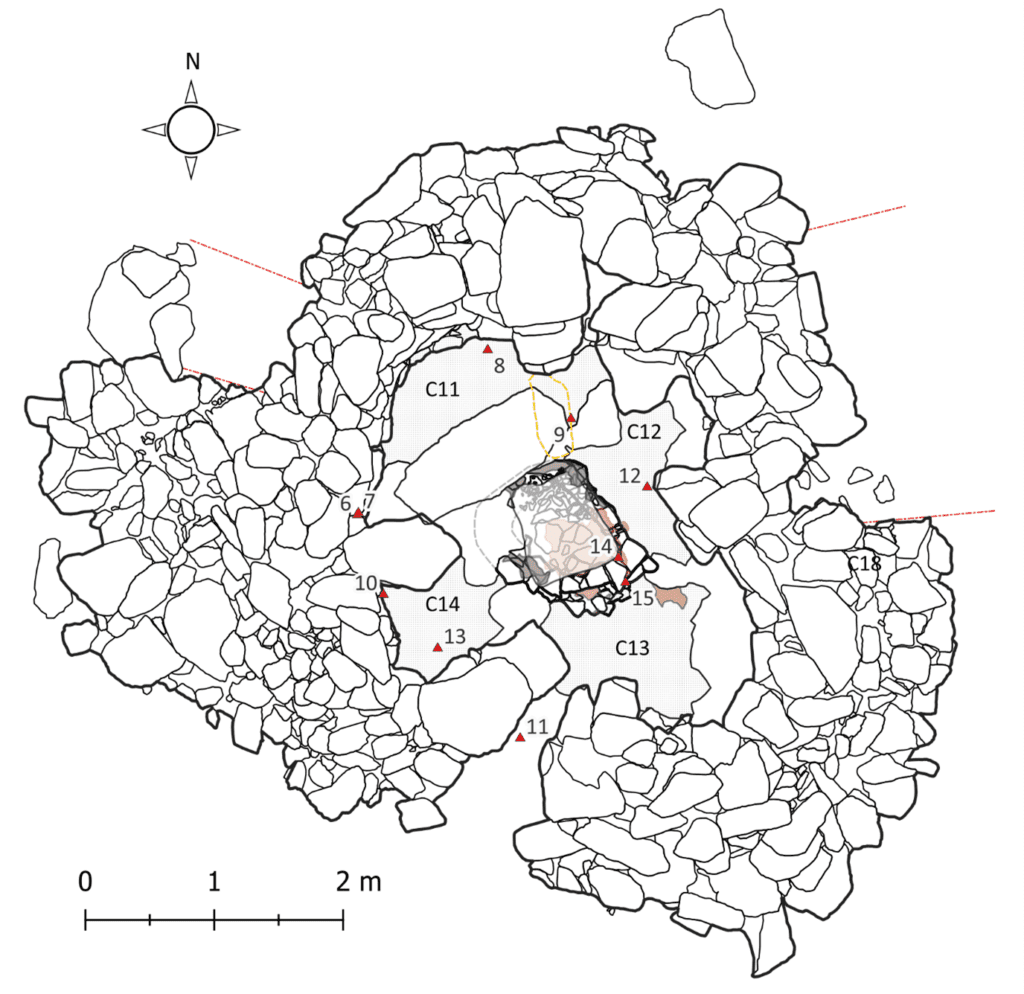
Plan of Structure D after the removal of the tumbled granite blocks, showing the location of Special Finds 6–15 (▲) and the planned extent of occupation layers C11, C12, C13 and C14. The possible original location of the fallen orthostat is shown in yellow.
The surfaces, the hearth construction and the walls of the structure overly a rough platform of angular and subangular granite stones and boulders, or in places the granite bedrock itself. This sloped down towards the south with a drop of almost a metre between the floor level at the back wall and in the entrance passage, but nevertheless the platform must have formed a relatively flat and solid foundation on which to construct a building.
No evidence of roofing materials was found, and it must be assumed that this was of some perishable material such as turf. The extant height of the stone walls, around 1.4m, may not be substantially reduced from their original height. The hearth structure was left in situ and the hearth stone reinstated after excavation, so as not to compromise the integrity or intelligibility of the structure. Despite the remote location, an open day attracted a number of visitors, predominantly the community archaeology group Archaeology Shetland, who were given a tour of the site as well as other significant archaeological features in the surrounding landscape.
The Finds
A total of 10 registered finds (numbered 6–15) were recovered during the excavation. Most were recovered from the surface of the floor/occupation deposits C11–C14. A non-local sandstone block SF13 and possible a placed deposit of felsite (C9/SF10) were found on the surface of C14, and a felsite block SF12 from C12. Most notable was a handled club (C10/SF8), found at the base of the south facing wall in the north-west alcove. Handled clubs have been found in domestic Bronze Age contexts across Orkney and Shetland.

Screenshot of 3D photogrammetric model of Structure B, (R. Montgomery) looking north-westThey are made almost exclusively from sandstone and are often broken or chipped, suggesting a functional purpose, although what that may be remains unknown (Clarke 2006: 58–59).
Structure B
Due to the proximity of protected nesting birds, it was not possible to excavate at Structure B, but the structure was recorded digitally using drone imagery and a 3D photogrammetric model. The structure itself has an irregular shape with no obvious parallels, although the relatively thin walls and presence of at least one linked subsidiary chamber does bear a superficial resemblance to the mid–late Bronze Age building excavated at Tougs, West Burra (Hedges et al. 1986: 4). The date of Structure B is not known and cannot be determined without excavation.
Significance of the Research
Almost no prehistoric houses have been excavated and recorded in Shetland using modern techniques. The work funded by the Society has significantly expanded what we know about the diversity of prehistoric buildings in Shetland. Notwithstanding any revisions based on the forthcoming radiocarbon dates, Structure D appears to represent a single phase of construction and use. The remote location of the structure and the lack of substantial occupation deposits might suggest that it was not constructed as a permanent dwelling, but perhaps as a much-needed shelter from the elements for people visiting North Roe to graze their sheep or collect felsite. The structure itself represents a sizable investment of labour, suggesting that the landscape was used regularly enough to warrant a permanent building. The presence of felsite chips within the building suggests that this material continued to be worked into the Bronze Age and people remained connected to the felsite-bearing landscape.
Acknowledgements
The Project team consisted of Dr Will Megarry FSAScot, Hazel Mosley, Astrid Rudjord and Ryan Montgomery. In addition to the Society of Antiquaries of Scotland, the project would like to thank Jenny Murray (Shetland Museum and Archives), Archaeology Shetland, Dr Val Turner (Shetland Regional Archaeologist) and others at the Shetland Amenity Trust.
Bibliography
Ballin, T B 2017 ‘North Roe felsite and Shetland’s felsite material culture – assemblages from quarry workshops and domestic settlements’, in Shaffrey, R (ed) Written in Stone. Papers on the function, form, and provenancing of prehistoric stone objects in memory of Fiona Roe. St Andrews: Highfield Press, 77–110.
Clarke, A 2006 Stone Tools and the Prehistory of the Northern Isles. BAR British Series 406. Oxford: BAR.
Cooney, G, Ballin, T B and Megarry, W 2011 ‘Objects for an island world, North Roe Felsite, Shetland’, in Mahler, D L (ed) The Border of Farming and the Cultural Markers. Queen’s University Belfast, 87-93.