The Society grant aided the detailed laser scanning of the Pictish symbol stone
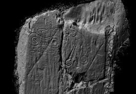
3D laserscan of inscribed stone at Trusty’s Hill
Trusty’s Hill is conspicuous amongst the hillforts of Galloway in that it contains a Pictish inscribed stone. A previous excavation of the site was undertaken by Charles Thomas in 1960, following an invitation from the Dumfriesshire and Galloway Natural History and Antiquarian Society. However, no evidence was encountered that could date the occupation of the fort; to demonstrate the status of its inhabitants; or to explicitly link the occupation of the fort with the carvings.
As part of the 150th anniversary of the founding of the Dumfriesshire and Galloway Natural History and Antiquarian Society, the Society launched a programme of excavation and survey of Trusty’s Hill Fort in 2012 in order to recover, for modern analysis, the environmental and dating evidence not recovered in the previous excavation and so enhance understanding of the archaeological context of the inscribed stone at Trusty’s Hill and the significance of this archaeological site within the context of Early Medieval Scotland.
The archaeological fieldwork comprised a topographic GPS survey to establish a modern plan and 3D model of the entirety of Trusty’s Hill; the re-excavation of previous excavation trenches and limited sample excavation in order to recover and record environmental and artefactual evidence from secure archaeological contexts and a detailed laser scan survey of the Pictish inscribed stone. The archaeological excavation was undertaken by 65 volunteers in collaboration with GUARD Archaeology Ltd, the Royal Commission on the Ancient and Historical Monuments of Scotland and the Centre for Digital Documentation and Visualisation LLP.
The topographic survey provides a modern accurate plan of the site that demonstrates that Trusty’s Hill comprises a fortified citadel around the summit of a craggy hill with a number of lesser enclosures looping out from the summit along lower lying terraces and crags of the hill. It therefore recognisably conforms to the definition of a nuclear fort.
Four of Thomas’ seven trenches were re-excavated. Trench 2 revealed a deep rock-cut basin on one side of the entrance to the hillfort, opposite the Pictish Inscribed Stone. This feature contained waterlogged deposits from which wood and other organic material was recovered for archaeobotanical analysis. Trench 4, on the east side of the interior summit of the site, encountered part of the vitrified rampart and associated ‘dark soil’ occupation deposits across an area of the interior. Excavation of these deposits recovered numerous animal bones, charcoal, worked stones and lithics, metalwork, metalworking debris and a rim sherd of 6th/7th century E-Ware. Trench 5 on the west side of the interior summit of Trusty’s Hill, also encountered part of the vitrified rampart along with associated occupation deposits also containing numerous animal bones, charcoal, worked stone and lithics, metalwork, metalworking debris, an Iron Age glass bead fragment and a rim sherd of 1st/2nd century Samian Ware. Trench 6 revealed the sterile fill of the rock-cut ditch on the north side of the site.
The 2012 excavations reached a greater depth than the 1960 excavations, demonstrating that the occupation deposits encountered in Trench 4 in 1960 overlay the collapsed rampart and may perhaps be better characterised as post-destruction deposits, while the stone rampart encountered in Trench 5 in 1960 was in fact the interior rubble collapse of the rampart rather than the rampart itself. The recovery of a significant number and quality of artefacts from the backfill of Trench 4, notably a disc brooch, also demonstrated that the 1960 excavation had not recovered the full artefactual assemblage contained within the deposits it encountered. However, this was almost certainly due to the scarce resources and torrential rain that the 1960 excavation endured throughout its duration. On the one day during the 2012 excavation during which it rained, it was noted that it was exceedingly difficult to observe artefacts in the now sticky dark soil deposits, even when sieving. Fortunately, the 2012 excavation was overwhelmingly conducted in ideal sunny dry conditions, which, together with greater volunteer and professional supervisory resources and the employment of a large dry sieving table for almost the entirety of the excavated soil deposits, maximised the recovery of artefacts. Other than topsoil, the only excavated soil deposits not sieved on site during the excavation, were those deposits taken for palaeo-environmental assessment. The subsequent process of wet-sieving, sorting and assessment recovered several important artefacts, including clay mould fragments and the glass bead, again maximising the recovery of artefacts from the 2012 excavation.
The radiocarbon dates obtained from the excavated material indicates initial occupation of Trusty’s Hill around 400 BC. However, it is unlikely that the vitrified rampart around the summit originates to this time, as an early sixth-early seventh century AD date was obtained from the construction layer beneath the rampart on the east side and another early sixth – mid seventh century AD date was taken from the vitrified rampart itself on the west side. Rather, it is more likely that the Iron Age material, such as the radiocarbon dated charcoal and glass bead fragment found within the foundation trench of the vitrified rampart on the west side, is residual, probably having been swept up from the interior of the site and laid out as a bed of material for the timber frame and stone core of the rampart. The Iron Age occupation of Trusty’s Hill appears to have been followed by a hiatus before the hill was re-occupied in the early fifth to early sixth century AD and fortified with a timber-laced rampart around its summit between the early sixth and mid seventh century AD. This rampart was destroyed probably around the end of this period in the early-mid seventh century AD. Furthermore, a date of AD 661-773 taken from the primary fill of the rock-cut basin opposite the Pictish Carvings demonstrates that the basin derives from at least the last phase of occupation and that use of this feature may have continued after the destruction of the fort. A record of several silver coins of Edward VI and Elizabeth I being found nearby to the Pictish Carvings in the Statistical Account of 1794 might suggest continued use of this votive well until as late as the sixteenth century.
The results of the laser scan survey of the inscribed stone still requires detailed specialist examination, but ogham is clearly not apparent along the southern edge of the inscribed stone. While this is in some ways disappointing, it nonetheless offers a correct and comprehensive depiction of the inscribed stone at Trusty’s Hill for the first time and corrects several more discrepancies from previous depictions and clearly shows that the horned head clearly cuts one of the inscribed signatures, demonstrating that the horned head is not ancient, but rather another element of the nineteenth century graffiti.
Comparisons can be drawn with the another Pictish Carving outside Pictland, that at Dunadd, the royal stronghold of the early Scots Kingdom of Dalriada. The nucleated fort layout of Trusty’s Hill, with an upper citadel and lower precincts, is similar to Dunadd. The material assemblage recovered from the 2012 excavation of Trusty’s Hill is closely comparable with Dunadd. Furthermore, the association of the rock-cut basin and the Pictish Carving with the entranceway to the summit is suggestive of a ritualised area as the immediate archaeological context for the Pictish Carvings at Trusty’s Hill. This is remarkably similar to the surrounding context of the Pictish Carving at Dunadd, where the inauguration stone, upon which the Pictish Inscription is carved, is associated with a small rock-cut basin and located at the entranceway to the summit enclosure.
The ongoing programme of post-excavation analyses, comprising specialist analysis of the artefacts and environmental evidence, will result in a new publication that will hopefully significantly enhance understanding of early medieval politics, power, economy and contacts in northern Britain during the early medieval period.
Dr Chris Bowles
Scottish Borders Council
Ronan Toolis
GUARD Archaeology Ltd
Help us: champion research; stimulate discussion; enhance public understanding; and share our extraordinary heritage. Donate directly to the Society now.